 Scoop has an Ethical Paywall


Warm And Windy, Wet For Some
Covering period of Thursday 9th - Monday 13th October
- Heavy persistent rain for the South
Island’s west coast
- Strong persistent northwesterly
winds for many
- Warm temperatures across the board,
muggy days and muggy nights
- A spring mix of unsettled
weather
Spring shows its true colours as we settle into a variable rhythm across Aotearoa New Zealand this week, delivering everything from heavy rain and gales to muggy nights and cloudy skies.
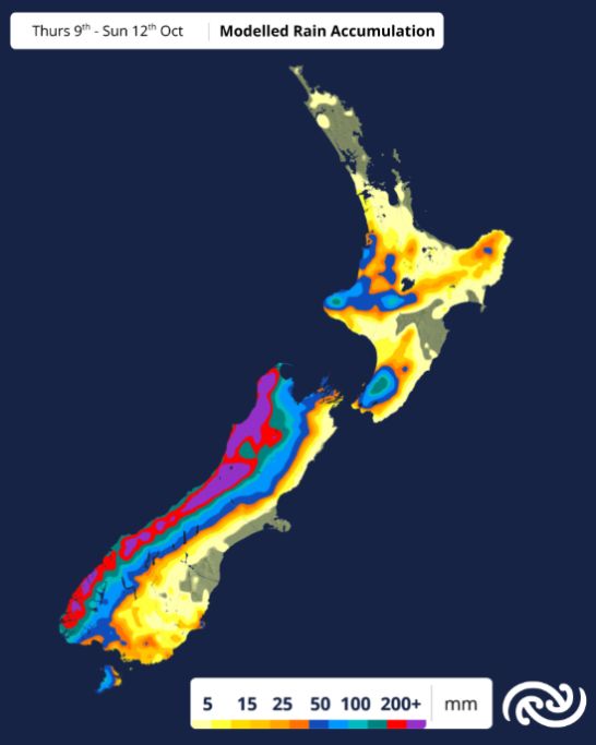
A warm, moisture-laden system is tracking over the country from the Tasman Sea, bringing long-lived rain to the West Coast of the South Island, where Heavy Rain Watches and Warnings are in place. Stalling over Buller tonight (Thursday), with a prolonged Heavy Rain Warning in place for the 37 hours from midnight tonight until 1 pm Saturday; expecting up to 350mm of rain to fall over that period. The largest accumulations are expected about the ranges.
Strong northwesterly winds are expected for the Canterbury High Country, with a Strong Wind Warning in effect today and tomorrow morning. Foehn winds are likely to make an appearance for Cantabrians, dry, gusty, and unseasonably warm. Fire Emergency New Zealand has a moderate fire risk in place for the region, so be sure to follow appropriate guidance if lighting fires.
MetService meteorologist Devlin Lynden explains:
“This is one of those weeks where west and east have very different experiences. While the West Coast braces for rain, places like North Otago, Canterbury and Marlborough could be drying out fast under gusty northwest winds, with temperatures hitting the mid 20’s for some. It’s a very spring-like-pattern.”
For the North Island, the weather doesn’t turn dramatic, but it does see its fair share of active weather. Persistent westerlies will continue to feed cloud and drizzly conditions into western parts of North Island, with limited sunshine and muggy nights. Temperatures of around 27 degrees are expected for the likes of Hastings on Friday, with lows hovering in the mid-teens across the board. A “grey and warm” combination for Kiwis to enjoy.
By the weekend, there’s not much shift in the setup. The West Coast sees a brief easing of rain on Saturday, only to be met by another front arriving from the south late in the day, bringing showers again by Sunday. Meanwhile, much of the North Island and eastern South Island continue with a mix of cloud, wind, and spring warmth.
Stay up to date with the latest forecasts and warnings at metservice.com, or on the MetService app.
 Gordon Campbell: On How US Courts Are Helping Donald Trump Steal The Mid-Terms
 Office of the Ombudsman: Ombudsman Publishes Findings On Ministry Of Education Sensitive Claims Scheme
 Nelson City Council: Mayor Welcomes Auditor-General Decision Not To Prosecute Councillor
 Johnnie Freeland: Ko Tātou Tātou - Climate Action In Aotearoa Begins With Relationship
 Zero Waste Network Aotearoa: Container Return Scheme Bill Would Double Recycling Rates And Put Money Back In Households
 Wellington City Council: Statement From The Wellington Mayoral Forum On Options For Regional Governance Reform
 MUNZ: TAIC Report On Kaitaki Incident Gives Shocking Picture Of Decline Of NZ Maritime Infrastructure