 Scoop has an Ethical Paywall


Community Representatives Sought For Lower Clutha Flood And Drainage Liaison Group
The Otago Regional Council (ORC) is continuing its work to re-establish liaison groups for flood protection and drainage schemes across the region, with a new group now being set up for the Lower Clutha.
ORC General Manager Science and Resilience, Tom Dyer, says "We’re looking forward to welcoming local voices to the Lower Clutha liaison group.”
“This is a chance for people in the community to share their knowledge, help guide scheme decisions and ensure the protection and management of our flood and drainage networks reflects local priorities."
The re-establishment of these groups follows a Council decision as part of the 2024 Long-Term Plan. The first, for the Lower Taieri flood protection and drainage schemes, was established in December 2024.
The Lower Clutha Flood Protection and Drainage Scheme Liaison Group will be established before the end of the year, serving as an informal committee to work alongside the Otago Regional Council. A similar liaison group for the Tokomairiro Drainage Scheme, centred on Milton, is planned for 2026.
“We are seeking representatives from Balclutha, Paretai, Barnego, Inch Clutha, and Kaitangata (one from each area) to join representatives from mana whenua, Contact Energy, Clutha District Council, and ORC,” Mr Dyer says.
| Party Representatives | Number of seats in each group |
| Balclutha | 1 |
| Paretai | 1 |
| Barnego | 1 |
| Inch Clutha | 1 |
| Kaitangata | 1 |
| Mana whenua | 2 |
| Contact Energy Limited | 1 |
| ORC Councillor | 1 |
| Clutha District Councillor | 1 |
| Total | 10 |
 |  |
Role of the group
- Provide feedback to ORC on levels of service and proposed operational and capital programmes.
- Provide input on infrastructure strategy, asset management plans, and rating/ funding proposals.
- Enable effective communication between scheme stakeholders.
Nominations and selection process
Liaison group representatives will be elected, with the group formalised at an AGM in December.
Nominations are open to everyone who lives in the scheme area and can be submitted at: orc.govt.nz/LowerCluthaGroup
Nominations will close at 11.59pm on Wednesday, 5 November.
Annual General Meeting
- Date: Thursday, 13 November
- Time: 6:30pm
- Location: Rosebank Lodge, 265 Clyde Street, Balclutha
Read the agenda for the AGM: https://www.orc.govt.nz/media/nr0l2ht2/lower-clutha-flood-protection-and-drainage-scheme-liaison-group-initial-agm-agenda.pdf
Read the draft terms of reference for the liaison group: https://www.orc.govt.nz/media/1nddcgzj/lower-clutha-flood-protection-drainage-scheme-liaison-group-draft-terms-of-reference.pdf
About the Lower Clutha Flood Protection and Drainage Scheme
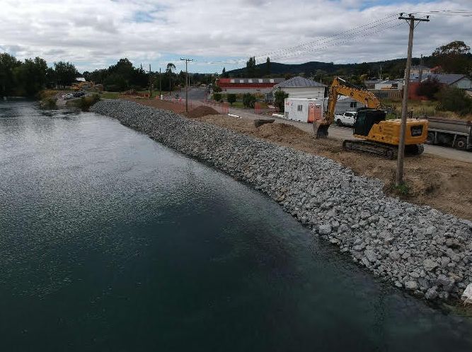
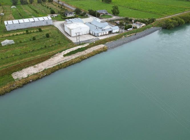
The Lower Clutha Flood Protection and Drainage Scheme is a cornerstone of flood management in South Otago, safeguarding communities and supporting productive farmland. Stretching from four kilometres upstream of Balclutha to the sea, the scheme was constructed between 1960 and 1991 to protect Balclutha, Kaitangata, Stirling, and surrounding low-lying land.
The scheme combines flood protection and drainage systems. Extensive floodbanks along the Clutha River/Mata-Au and its tributaries help prevent floodwaters from spilling onto farmland, while a network of pumps, channels, and culverts manages internal runoff to maintain arable land conditions.
The Clutha River/Mata-Au — New Zealand’s second longest river and largest by average flow — originates in the Southern Alps above lakes Whakatipu, Wānaka, and Hāwea.
Just below Balclutha, it divides into the Koau and Matau branches, with Inch Clutha lying between them. A dedicated floodway at the island’s head provides critical capacity to carry excess water during high flows.
The flood protection and drainage schemes outlined above are in place to protect:
- 9,300 ha of land
- Four bridges
These schemes include the following infrastructure:
- 153 km of open drains
- 110 km of flood banks
- 189 culverts
- Five pump stations
Further information on the formation of this new liaison group and the nomination form can be found on ORC’s website.
 Gordon Campbell: On The Political Panic Over Immigration
 MUNZ: TAIC Report On Kaitaki Incident Gives Shocking Picture Of Decline Of NZ Maritime Infrastructure
 Greenpeace: New Climate Report Yet More Reason To Reduce Dairy Herd
 Better Public Media: Opposing Plans To Scrap The BSA
 Internal Affairs: Citizenship Test For Citizenship By Grant Applicants From Late 2027
 Dayenu: Condemning Use Of Government Funding For Extremist Report On Antisemitism
 PSA: Councils Must Work With Unions And Communities In Fast-Track Reform