 Scoop has an Ethical Paywall


MetService Issues Red Warning For Canterbury And Wellington
22/10/2025
Covering
period of Wednesday 22nd - Thursday 23rd October
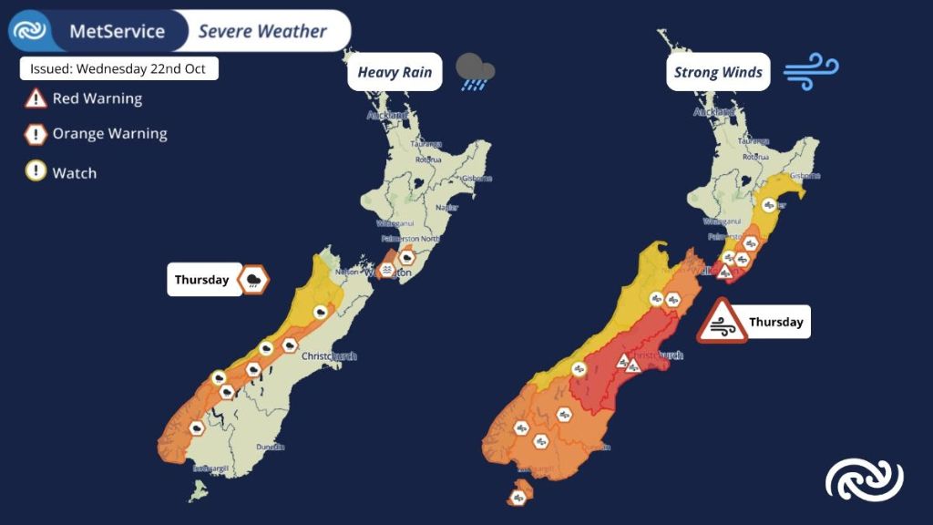
At 9:59am MetService escalated the Severe Weather Warnings in Canterbury, including Christchurch, Wellington, and South Wairarapa to Red Warnings for Damaging Winds in consultation with the respective regional councils.
All MetService warnings have the potential for impacts, but Red Warnings are reserved for the most extreme weather events where significant impact and disruption is expected.
The escalation to a Red Warning comes as impacts were already felt on Tuesday with the first of two significant weather systems anticipated this week, with Thursday looking more intense and more widespread.
MetService meteorologist Mmathapelo Makgabutlane says, “Thursday has a similar but stronger flavour. While some areas may have escaped the impacts earlier in the week, Thursday’s winds are expected to be more widespread and could affect places that don’t often see strong winds.”
These destructive winds can cause threat to life from flying items and falling trees, widespread damage including powerlines and roofs, with dangerous driving conditions and significant disruption to transport and power supply. Northwesterly wind speeds of 150 km/h are possible for exposed parts of Canterbury High Country, 140 km/h for Wellington and Wairarapa, and 130 km/h for the Canterbury Plains and Christchurch.
“The public are advised to take the opportunity today (Wednesday) to prepare for the significant and damaging winds on Thursday. Secure any loose items, make sure batteries are charged. Once it kicks off on Thursday, stay indoors or seek sturdy shelter away from trees. Avoid unnecessary travel. Be ready for power and communication outages,” Makgabutlane advises.
“A Red Warning signifies that people need to act now as immediate action is required to protect people, animals and property from the impact of the weather. People should also be prepared to follow the advice of official authorities and emergency services.”
This is the fourth round of Red Warnings MetService has issued this year, and it’s the 19th Red Warning weather event since the highest alert level was introduced back in May 2019.
It’s not just Canterbury and Wellington which are lined up for severe weather. Orange Strong Wind Warnings are in place for the rest of the South Island, including Marlborough and the Kaikōura Coast, which have a high chance of upgrade to Red. The West Coast Region, as well as Tasman and Nelson are under Yellow Watches.
Additionally, heavy rain spreads up the South Island, including places that were impacted on Tuesday. Orange Heavy Rain Warnings are in place for the ranges of Westland, the headwaters of the Canterbury and Otago lakes and rivers, as well as Fiordland. Further impacts such as slips, surface flooding, difficult driving conditions and travel disruptions are likely. This time around, the rain will move through quicker but will also be more intense and rivers are likely to respond faster than on Tuesday. Coastal Westland, Grey, Buller, Tasman, Nelson and the Nelson Lakes National Park are all under a Watch for Heavy Rain.
In the North Island, Orange Wind Warnings are in place for the remainder of Wairarapa and the Tararua District. Hawke’s Bay is under a Yellow Watch as northwest winds may approach severe gale on Thursday, along with the dry conditions and warm temperatures. The Tararua Range is also under an Orange Heavy Rain Warning. Details about all of these are illustrated in more detail on our webpage; https://www.metservice.com/warnings/home
Once Thursday is done, many people will be looking ahead to Labour Day weekend. For those traveling, be aware that Monday sees another potentially disruptive weather system which may impact travel.
Keep up to date with weather and warnings via metservice.com or our free MetService weather app.
MetService also now provides push notifications for Red Severe Weather Warnings via our app. More information can be found here about enabling them.
Understanding MetService Severe Weather Warning System
Severe Thunderstorm Warnings (Localised Red Warning) - take cover now:
- This warning is a red warning for a localised area.
- When extremely severe weather is occurring or will do within the hour.
- Severe thunderstorms have the ability to have significant impacts for an area indicated in the warning.
- In the event of a Severe Thunderstorm Red Warning: Act now!
Red Warnings are about taking immediate action:
- When extremely severe weather is imminent or is occurring
- Issued when an event is expected to be among the worst that we get – it will have significant impact and it is possible that a lot of people will be affected
- In the event of a Red Warning: Act now!
Orange Warnings are about taking action:
- When severe weather is imminent or is occurring
- Typically issued 1 - 3 days in advance of potential severe weather
- In the event of an Orange Warning: Take action.
Thunderstorm Watch means thunderstorms are possible, be alert and consider action
- Show the area that thunderstorms are most likely to occur during the validity period.
- Although thunderstorms are often localised, the whole area is on watch as it is difficult to know exactly where the severe thunderstorm will occur within the mapped area.
- During a thunderstorm Watch: Stay alert and take action if necessary.
Watches are about being alert:
- When severe weather is possible, but not sufficiently imminent or certain for a warning to be issued
- Typically issued 1 - 3 days in advance of potential severe weather.
- During a Watch: Stay alert
Outlooks are about looking ahead:
- To provide advanced information on possible future Watches and/or Warnings
- Issued routinely once or twice a day
- Recommendation: Plan
 Gordon Campbell: On How US Courts Are Helping Donald Trump Steal The Mid-Terms
 Office of the Ombudsman: Ombudsman Publishes Findings On Ministry Of Education Sensitive Claims Scheme
 Nelson City Council: Mayor Welcomes Auditor-General Decision Not To Prosecute Councillor
 Johnnie Freeland: Ko Tātou Tātou - Climate Action In Aotearoa Begins With Relationship
 Zero Waste Network Aotearoa: Container Return Scheme Bill Would Double Recycling Rates And Put Money Back In Households
 Wellington City Council: Statement From The Wellington Mayoral Forum On Options For Regional Governance Reform
 MUNZ: TAIC Report On Kaitaki Incident Gives Shocking Picture Of Decline Of NZ Maritime Infrastructure