 Scoop has an Ethical Paywall


Heavy Rain, Strong Winds, Then A Sharp Cool Change For The Week Ahead
15/12/2025
Covering
period of Monday 15th - Thursday 18th
December
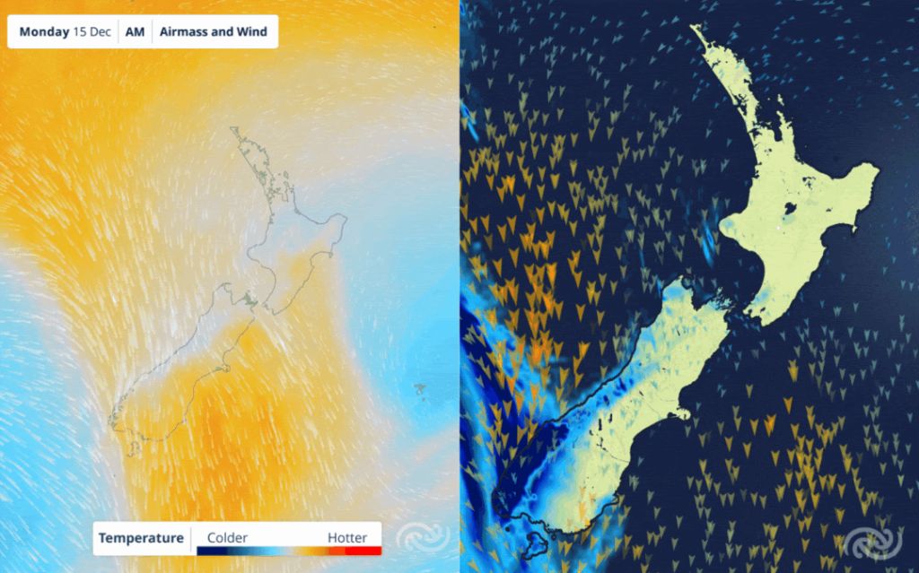
- Heavy rain and severe northwest winds are affecting parts of the South Island today
- Rain and strong winds spread to the North Island on Tuesday.
- Cool temps and showery conditions expected from Wednesday.
The final full week before Christmas is upon us, and holidays have already started for some, but the weather has decided it’s not quite time to relax yet. After a settled weekend, an active cold front has begun moving up the South Island today (Monday) and approaches the North Island on Tuesday morning, bringing periods of heavy rain and strong northwesterlies, followed by a cooler unstable southwesterly flow.
The South Island is in the thick of it today and tomorrow, particularly those in western areas where there is a range of Heavy Rain Warnings & Watches in place today and into the early hours of Tuesday morning. Along with rain, strong northwesterlies are forecast, with Strong Wind Warnings in place for Fiordland and the Canterbury High Country today, as well as a Strong Wind Watch in place for Queenstown Lakes District, Central Otago and inland areas of Southland, Clutha and Dunedin. Following the front, large parts of the South Island will see the risk of thunderstorms and hail on Tuesday.
The north sees a more settled Monday than the south, however, that front moves onto the North Island midday Tuesday which will bring strong northwesterlies for exposed western areas and a period of rain of many places through Tuesday afternoon and evening. That rain will be welcomed for many as recent hot and dry conditions have seen water restrictions and elevated fire risk for places like the Hawke’s Bay. Head to checkitsalright.nz to check the current fire risk in your area.
MetService Meteorologist Devlin Lynden says, “Looking ahead, there will certainly be a cool shift this week as that front crosses the country and we reset into a more variable, unsettled and showery weather pattern.”
Once that front has moved on, the weather remains a bit of a mixed bag as a cool south to southwesterly flow moves in behind it. This will bring a dramatic shift from the high temperatures felt last week. Come Wednesday and Thursday many places will struggle to make it into the twenties as those southwesterlies keep the temperatures capped. With places like Dannevirke, Wellington, Ashburton, Oamaru and Invercargill expected to top out at only 16°C on Wednesday.
“While it might feel like we are headed for a ‘white Christmas’ for some this week, it’s worth remembering that we’re still firmly in summer. Christmas Day is ten days away, and with the country settling into a more changeable pattern, the longer-range forecasts are likely to change in the lead up to the big day as the weather story becomes clearer,” States Lynden.
Forecast confidence will improve closer to Christmas, so keep an eye on the latest forecasts at metservice.com or on the MetService app.
Understanding MetService Severe Weather Warning System
Severe Thunderstorm Warnings (Localised Red Warning) - take cover now:
- This warning is a red warning for a localised area.
- When extremely severe weather is occurring or will do within the hour.
- Severe thunderstorms have the ability to have significant impacts for an area indicated in the warning.
- In the event of a Severe Thunderstorm Red Warning: Act now!
Red Warnings are about taking immediate action:
- When extremely severe weather is imminent or is occurring
- Issued when an event is expected to be among the worst that we get – it will have significant impact and it is possible that a lot of people will be affected
- In the event of a Red Warning: Act now!
Orange Warnings are about taking action:
- When severe weather is imminent or is occurring
- Typically issued 1 - 3 days in advance of potential severe weather
- In the event of an Orange Warning: Take action.
Thunderstorm Watch means thunderstorms are possible, be alert and consider action
- Show the area that thunderstorms are most likely to occur during the validity period.
- Although thunderstorms are often localised, the whole area is on watch as it is difficult to know exactly where the severe thunderstorm will occur within the mapped area.
- During a thunderstorm Watch: Stay alert and take action if necessary.
Watches are about being alert:
- When severe weather is possible, but not sufficiently imminent or certain for a warning to be issued
- Typically issued 1 - 3 days in advance of potential severe weather.
- During a Watch: Stay alert
Outlooks are about looking ahead:
- To provide advanced information on possible future Watches and/or Warnings
- Issued routinely once or twice a day
- Recommendation: Plan
 Gordon Campbell: On How US Courts Are Helping Donald Trump Steal The Mid-Terms
 Office of the Ombudsman: Ombudsman Publishes Findings On Ministry Of Education Sensitive Claims Scheme
 Nelson City Council: Mayor Welcomes Auditor-General Decision Not To Prosecute Councillor
 Johnnie Freeland: Ko Tātou Tātou - Climate Action In Aotearoa Begins With Relationship
 Zero Waste Network Aotearoa: Container Return Scheme Bill Would Double Recycling Rates And Put Money Back In Households
 Wellington City Council: Statement From The Wellington Mayoral Forum On Options For Regional Governance Reform
 MUNZ: TAIC Report On Kaitaki Incident Gives Shocking Picture Of Decline Of NZ Maritime Infrastructure