 Scoop has an Ethical Paywall


MetService Issues Red Warnings For Significant Rain
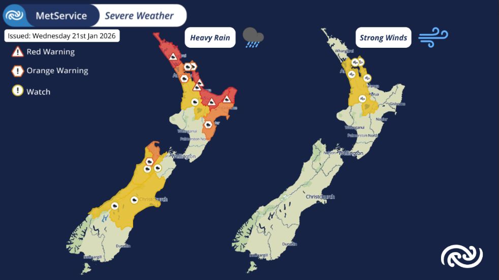
At 9:08am MetService escalated the Severe Weather Warnings in Northland, Coromandel, Bay of Plenty, and northern Tairāwhiti Gisborne to Red Warnings for significant rainfall, in consultation with the respective regional councils.
All MetService warnings have the potential for impacts, but Red Warnings are reserved for the most extreme weather events where significant impact and disruption are expected.
The escalation to a Red Warning comes off the back of already impactful heavy rain over the past few days. The upper North Island is in the throes of a prolonged heavy rain event, while a tropical low approaches the country, arriving today (Wednesday).
The Red Warnings are valid from 9:00 am Wednesday and go until 11:00 pm in Northland, 3:00 am Thursday in Coromandel, while Bay of Plenty and northern Tairāwhiti Gisborne go to 9:00 am and 11:00 am Thursday respectively.
Parts of Northland have already seen more than 300 mm of rain since the start of Sunday, with a further 120 mm possible today. Coromandel has received 150 to 200 mm of rain in 24 hours with impacts already felt, and a further 200 to 250 mm is possible on top of what has already fallen. Bay of Plenty could see a further 240 mm, while Gisborne may see 250 to 350 mm. Periods of intense downpours are also likely.
MetService meteorologist Mmathapelo Makgabutlane says, “With rain falling onto already sodden ground, widespread impacts such as significant flooding, slips, dangerous river conditions, and hazardous road conditions and travel disruptions are likely. These can lead to areas being cut off, as well as danger to life.”
“A Red Warning signifies that people need to act now as immediate action is required to protect people, animals and property from the impact of the weather. People should also be prepared to follow the advice of official authorities and emergency services.”
This is the first Red Warning MetService has issued this year. It is the 20th Red Warning weather event since the highest alert level was introduced back in May 2019.
In addition, Auckland, the rest of Tairāwhiti Gisborne, as well as Hawke’s Bay may see impactful rainfall and are under Orange Heavy Rain Warnings.
Wet weather is possible over the South Island today and on Thursday. Tasman west of Mapua is under an Orange Heavy Rain Warning, while Watches are in place for Nelson, Westland, and Canterbury including Christchurch.
Meanwhile, strong easterly to northeasterly winds are also expected over the North Island. Strong Wind Watches are in place for Wednesday and early Thursday covering Auckland and all of Waikato, including Coromandel. All Warnings and Watches are all illustrated in more detail on our webpage; https://www.metservice.com/warnings/home.
“These impacts are likely to be long and far-reaching and may run into the long weekend ahead for popular holiday hotspots. Be sure to stay up to date with your local Civil Defence, especially if you’re planning to travel,” Makgabutlane advises.
Severe weather can increase traffic to the website which can slow it down. If you experience performance issues, you can keep up to date via our free MetService weather app. The app also provides push notifications for Red Severe Weather Warnings. More information about enabling them can be found here: https://metservice.us11.list-manage.com/track/click?u=63982abb40666393e6a63259d&id=ec075aa445&e=9c25c1a89a
Understanding MetService Severe Weather Warning System
Severe Thunderstorm Warnings (Localised Red Warning) - take cover now:
- This warning is a red warning for a localised area.
- When extremely severe weather is occurring or will do within the hour.
- Severe thunderstorms have the ability to have significant impacts for an area indicated in the warning.
- In the event of a Severe Thunderstorm Red Warning: Act now!
Red Warnings are about taking immediate action:
- When extremely severe weather is imminent or is occurring
- Issued when an event is expected to be among the worst that we get – it will have significant impact and it is possible that a lot of people will be affected
- In the event of a Red Warning: Act now!
Orange Warnings are about taking action:
- When severe weather is imminent or is occurring
- Typically issued 1 - 3 days in advance of potential severe weather
- In the event of an Orange Warning: Take action.
Thunderstorm Watch means thunderstorms are possible, be alert and consider action
- Show the area that thunderstorms are most likely to occur during the validity period.
- Although thunderstorms are often localised, the whole area is on watch as it is difficult to know exactly where the severe thunderstorm will occur within the mapped area.
- During a thunderstorm Watch: Stay alert and take action if necessary.
Watches are about being alert:
- When severe weather is possible, but not sufficiently imminent or certain for a warning to be issued
- Typically issued 1 - 3 days in advance of potential severe weather.
- During a Watch: Stay alert
Outlooks are about looking ahead:
- To provide advanced information on possible future Watches and/or Warnings
- Issued routinely once or twice a day
- Recommendation: Plan
 Gordon Campbell: On How US Courts Are Helping Donald Trump Steal The Mid-Terms
 Office of the Ombudsman: Ombudsman Publishes Findings On Ministry Of Education Sensitive Claims Scheme
 Nelson City Council: Mayor Welcomes Auditor-General Decision Not To Prosecute Councillor
 Johnnie Freeland: Ko Tātou Tātou - Climate Action In Aotearoa Begins With Relationship
 Zero Waste Network Aotearoa: Container Return Scheme Bill Would Double Recycling Rates And Put Money Back In Households
 Wellington City Council: Statement From The Wellington Mayoral Forum On Options For Regional Governance Reform
 MUNZ: TAIC Report On Kaitaki Incident Gives Shocking Picture Of Decline Of NZ Maritime Infrastructure