 Scoop has an Ethical Paywall


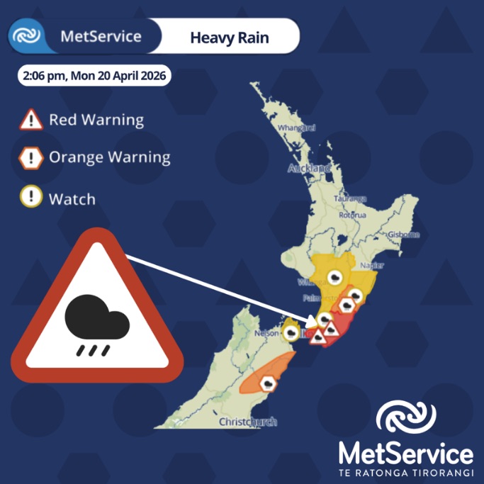
MetService Red Heavy Rain Warnings For Wellington And Wairarapa And Weather For The Remainder Of New Zealand
20/05/2026
Covering period of Monday
20th April - Thursday 23rd April
At 2pm MetService escalated the severe weather warnings in Wellington and Wairarapa to Red Warnings for heavy rain, in consultation with local Regional Councils.
All MetService warnings have the potential for impacts, but Red Warnings are reserved for the most extreme weather events where significant impact and disruption are expected.
The escalation to Red Warnings comes off the back of significant weather impacts occurring for much of the weekend, in parts of the country. Downpours due to thunderstorm activity were seen over the weekend, and early this morning for Wellington, followed by continuous heavy rain feeding into the middle of the country, with more expected to spread into Wairarapa. This rain is prolonged, with the risk of continued heavy falls and downpours.
The Red Heavy Rain Warning for Wellington and the Hutt Valley, excluding Porirua, goes from 2pm Monday through to 9pm Tuesday. A further 100 to 150mm can be expected around the Hutt Valley with lesser amounts elsewhere. These amounts are in addition to the rain that has already fallen. Peak rates of 15 to 25 mm/h but 25 to 40 mm/h are possible in localised places until tonight (Monday), especially in thunderstorms.
The Red Heavy Rain Warning for Wairarapa is valid from 2pm through to midnight Tuesday. The heaviest rainfall is forecast for Wairarapa, with between 80 to 120mm of rainfall expected, but 200 to 280mm about the ranges and coastal hills. Peak rates of 15 to 25 mm/h, but 25 to 40 mm/h possible in localised places, especially in thunderstorms. With king tides expected this week, take extra care and caution around river mouths at high tide.
MetService meteorologist Katie Lyons says, “Following the severe downpours over the last few days and the upcoming forecast rainfalls, there is an increased threat to life from dangerous river conditions, significant flooding and slips, with especially hazardous driving conditions. Some roads may become impassable, isolating communities”. Do not enter floodwaters and avoid travel. Act quickly to self-evacuate if you see rising water. Be ready for power and communications outages.
“A Red Warning signifies that people need to act now as immediate action is required to protect people, animals and property from the impact of the weather. People should also be prepared to follow the advice of official authorities and emergency services”, says Lyons.
This is the fifth Red Warning event MetService has issued this year, and it’s the 24th Red Warning weather event since the highest alert level was introduced back in May 2019.
A Yellow Strong Wind Watch is also in place for Wellington, the Kapiti Coast and the Marlborough Sounds for gale force south to southeast winds from 3pm today (Monday) through 9pm Tuesday. These strong southerlies will also spread up to Taranaki, with a Yellow Wind Watch from 9pm tonight (Monday) – 9pm Tuesday.
Weather for the remainder of New Zealand
Many other areas around Aotearoa are under the influence of severe weather, some more localised, with risks in thunderstorms further north, and some more broadscale, with wider warnings.
An Orange Heavy Rain Warning is currently in place for the Kaikoura Coast and Ranges and northern Canterbury through to 11pm tonight (Monday). This Heavy Rain Warning is brought on by moist persistent southeasterlies driving rainfall up into the ranges. A Heavy Rain Watch is in place for the Marlborough Sounds through to 11pm Monday, and also the Kapiti Coast from 6pm Monday to 9pm Tuesday.
An Orange Heavy Rain Warning is in place for the Tararua District until midnight Tuesday. This rainband tracks northwards to the Tararua District today Hawke’s Bay on Tuesday and Gisborne on Wednesday. A Heavy Rain Watch has been issued for southern Hawke’s Bay already from 6pm Monday – Midnight Tuesday, with the chance of more Heavy Rain Watches and Warnings being added as the rain continues to track north.
Bands of heavy showers continue, with possible thunderstorms and hail, today (Monday) from Wanganui, Manawatu and Hawke’s Bay northward. This sort of weather is more localised, so even without broadscale warnings, impacts can still be seen.
Severe Thunderstorm Warnings were issued in Northland overnight and Bay of Plenty this morning (Monday), with heavy rain and wind gusts up to 115km/h recorded as they moved through. South of the Central Plateau, rain settles in tomorrow (Tuesday). To the north these showers continue but become more sparce and less heavy with a decrease in the risk of thunderstorms.
Snow is on the cards for Lewis Pass and Porters Pass in northern Canterbury as freezing levels lower today (Monday) and overnight. “With clearer weather on the horizon toward Wednesday for the South Island, this dusting of snow will give a great Autumn backdrop”, says Lyons. “A distinct chill in the air can already be felt spreading up the country with these southerlies, and that will continue through the rest of the week”, Lyons adds.
The North Island will take a little bit longer to fine up, but the settling presence of a ridge of high pressure will begin to be felt by Thursday, with the weekend looking promising.
Keep up to date with weather and warnings via metservice.com or our free MetService weather app.
MetService also now provides push notifications for Red Severe Weather Warnings via our app. More information can be found here (https://metservice.us11.list-manage.com/track/click?u=63982abb40666393e6a63259d&id=b7a87402ee&e=9c25c1a89) about enabling them.
Understanding MetService Severe Weather Warning System
Severe Thunderstorm Warnings (Localised Red Warning) - take cover now:
- This warning is a red warning for a localised area.
- When extremely severe weather is occurring or will do within the hour.
- Severe thunderstorms have the ability to have significant impacts for an area indicated in the warning.
- In the event of a Severe Thunderstorm Red Warning: Act now!
Red Warnings are about taking immediate action:
- When extremely severe weather is imminent or is occurring
- Issued when an event is expected to be among the worst that we get – it will have significant impact and it is possible that a lot of people will be affected
- In the event of a Red Warning: Act now!
Orange Warnings are about taking action:
- When severe weather is imminent or is occurring
- Typically issued 1 - 3 days in advance of potential severe weather
- In the event of an Orange Warning: Take action.
Thunderstorm Watch means thunderstorms are possible, be alert and consider action
- Show the area that thunderstorms are most likely to occur during the validity period.
- Although thunderstorms are often localised, the whole area is on watch as it is difficult to know exactly where the severe thunderstorm will occur within the mapped area.
- During a thunderstorm Watch: Stay alert and take action if necessary.
Watches are about being alert:
- When severe weather is possible, but not sufficiently imminent or certain for a warning to be issued
- Typically issued 1 - 3 days in advance of potential severe weather.
- During a Watch: Stay alert
Outlooks are about looking ahead:
- To provide advanced information on possible future Watches and/or Warnings
- Issued routinely once or twice a day
- Recommendation: Plan
 Gordon Campbell: On How US Courts Are Helping Donald Trump Steal The Mid-Terms
 Office of the Ombudsman: Ombudsman Publishes Findings On Ministry Of Education Sensitive Claims Scheme
 Nelson City Council: Mayor Welcomes Auditor-General Decision Not To Prosecute Councillor
 Johnnie Freeland: Ko Tātou Tātou - Climate Action In Aotearoa Begins With Relationship
 Zero Waste Network Aotearoa: Container Return Scheme Bill Would Double Recycling Rates And Put Money Back In Households
 Wellington City Council: Statement From The Wellington Mayoral Forum On Options For Regional Governance Reform
 MUNZ: TAIC Report On Kaitaki Incident Gives Shocking Picture Of Decline Of NZ Maritime Infrastructure