 Scoop has an Ethical Paywall


50 Years Ago: Inangahua Quake Jolted NZ Out of Complacency
Inangahua Quake Jolted NZ Out of Complacency
This week marks the 50th anniversary of the magnitude 7.1 Inangahua earthquake and scientists are among those reflecting on how much progress has been made in the world of earthquake science since 1968.
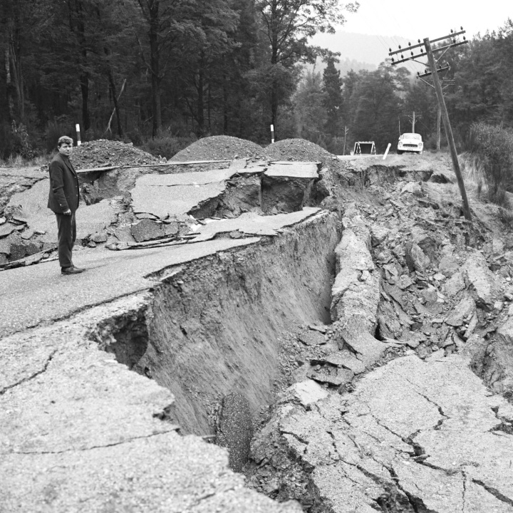
Inangahua-quake:
Geologist John Foster surveys damage to State Highway 7 near
Reefton Saddle, about 30km south of Inangahua, a couple of
days after the magnitude 7.1 earthquake in 1968. Photo –
Lloyd Homer, GNS Science
It would be unthinkable
today, but it took about six hours before the epicentre of
the Inangahua quake was known with any confidence. And its
magnitude took even longer. Today that all happens within a
few minutes of an earthquake and the information is made
available publicly straight away.
When Inangahua happened there had not been a large damaging earthquake in New Zealand for 26 years and there was an element of complacency about natural hazards.
The pre-dawn jolt at 5.24am on 24 May 1968 resulted in three deaths and 14 injuries. Two people were killed in one of the many landslides and the other death occurred when a motorist hit a bridge abutment in the dark. A further three people died when a rescue helicopter crashed.
The earthquake left 70 percent of the houses in the township of Inangahua – population 260 – uninhabitable. It damaged or destroyed 50 bridges and twisted railway tracks so badly that 100km of railway line had to be relayed.
Roads were cut off in all directions, phones were out of action, and there was no electricity. So locals had no way of communicating with the outside world. Eventually a truck driver in Inangahua managed to contact a colleague in Gisborne on his vehicle radio.
The first radio news bulletins reported that tremors were felt throughout New Zealand. There was initially no mention of the South Island’s West Coast.
Former chief seismologist with GNS Science Warwick Smith, now retired, recalls that there were just two paper drum seismographs operating in New Zealand in 1968. One in the Seismological Observatory in Wellington and the other at Canterbury Museum.
When staff arrived at work to check the instrument in Wellington, they found the force of the main shock had shot the pen right off the paper and splattered black ink on the surrounding area.
“From the gap between the P and S waves on the paper, scientists could tell the epicentre was about 200 kilometres from Wellington but they weren’t sure in which direction. It soon became apparent that it wasn’t to the north,” Dr Smith said.
As reports began to come in, attention focussed on the Buller region on the West Coast. This was confirmed by aerial reconnaissance by an electricity company reporting that the most severe damage in the landscape appeared to be around the Inangahua Valley.
It was nearly half a day before scientists knew the epicentre of the earthquake with any confidence.
In addition to the two paper drum seismic recorders, there were about 20 photographic recorders around the country located at places such as power stations and light houses. One sheet of photo paper was equivalent to 24 hours of recording.
An operator would change the paper every day and at the end of the week all seven papers were developed in a dark room and posted to Wellington for analysis by scientists.
“It was extremely tedious work. You had to manually measure all the seismic traces and then work out magnitudes and locations. At best, the information about individual earthquakes was about eight days old by the time it became available,” Dr Smith said.
“It’s important to note that the purpose of the network in the 1960s and 1970s was not to produce rapid information. It was for obtaining data for scientific research. If any rapid information became available, that was a bonus.”
Fast forward to 2018 and the GeoNet project operates about 650 instruments in its nationwide monitoring network. About half are seismometers sending their data in real time to GeoNet headquarters continuously.
GeoNet, which started in 2001, is operated by GNS Science and is funded largely by the Earthquake Commission. Its nationwide network enables the quick location of earthquakes and the information is broadcast to all New Zealanders via the GeoNet website, app, and social media.
There is huge uptake for this information, particularly during big events. For example, traffic to the GeoNet website following the November 2016 magnitude 7.8 Kaikoura earthquake peaked at 35,000 hits second.
Geologist Simon Nathan, who was a fresh graduate in 1968 and one of the first scientists on the scene after the quake, made a priority of getting an extensive photographic record of the damage. It was his first job out of university working for the Geological Survey of NZ, now GNS Science.
“When the earthquake struck, I was astonished by its force. I had to hold on to the side of my bed to stop myself falling out.
“There hadn’t been a big earthquake in New Zealand since 1942 and it was an exciting experience for a young geologist to witness such a massive upheaval of the landscape.”
The experience made a lasting impression on Dr Nathan and to this day he remains cautious about buying a house that could be prone to earthquake damage.
He said the quake initiated significant improvements to building standards, the planning a siting of infrastructure, and to the way civil defence operates. These improvements have continued incrementally ever since.
Earthquake geology specialist and principal scientist at GNS Science, Kelvin Berryman, said the earthquake had a major positive impact on geological studies of past big earthquakes and for understanding earthquake hazards in New Zealand.
“It boosted efforts to map active faults throughout New Zealand and to set up instrument monitoring networks across active faults to investigate the nature of strain build-up and release,” Dr Berryman said.
“The surface fault movements associated with the Inangahua earthquake were very complex, much more complicated than had been observed in previous earthquakes in places such as Marlborough and Wairarapa.
“So in 1968 it was very difficult to answer the question as to which fault was responsible for the earthquake.”
The main fault rupture that cased the earthquake did not break the surface and it took many years of work by scientists to understand the deep geological structure and to explain the nature and mechanism of the main shock at Inangahua.
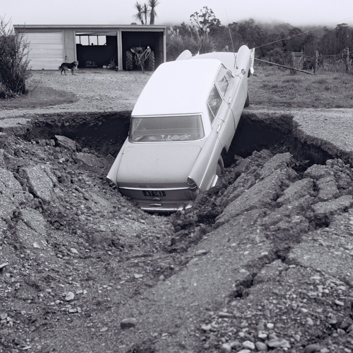
Inangahua-quake2: A car is
partly swallowed by a large pothole caused by the collapse
of a drainage tunnel in Inangahua. Photo – Lloyd Homer,
GNS Science
In this YouTube video, retired
geologist Simon Nathan recalls his experience at the scene
of the earthquake in 1968: https://youtu.be/q6ak1krtiXA
END
 Bill Bennett: Fixed Voice Rules Head For Deregulation
 UN Department of Global Communications: United Nations Proposes New Global Dashboard To Measure Progress Beyond GDP
 Banking Ombudsman Scheme: Fraud Check Delays Well Worth The Inconvenience, Says Banking Ombudsman
 Asia Pacific AML: NZ’s Financial Crime Gap - Beyond The 'Number 8 Wire' Mentality
 Westpac New Zealand: Kiwi Households Adapting Despite Widespread Cost Pressure Concerns, Westpac Survey Shows
 University of Auckland: Kids’ Screen Use Linked To Long-Term Deficits In Self-Control And Attention