Changeable weather continues into the weekend
MetService News
Release
12/12/19
Changeable weather continues into the weekend
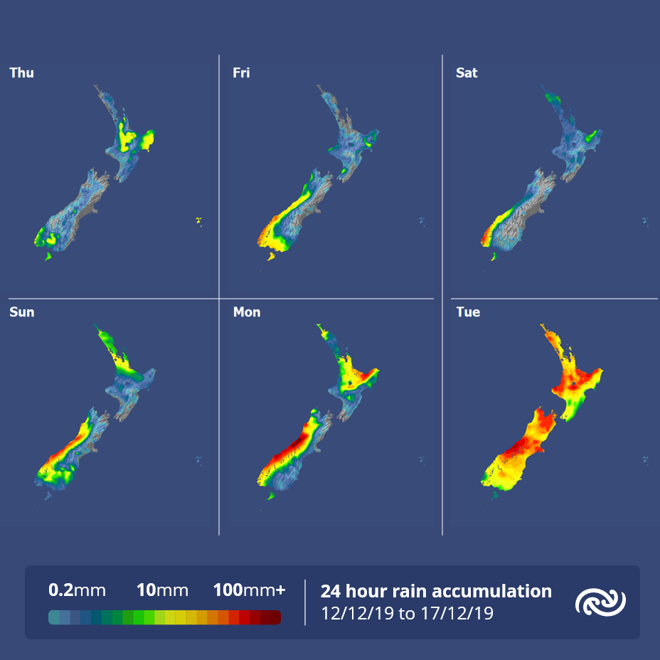
Changeable, Spring-like weather is forecast over the next week. Fast-moving weather features tracking up the country will bring showers to many, but rain to western areas of South Island, for the remainder of this week and into the weekend.
MetService has issued a Severe Thunderstorm Watch for parts of the North Island, for this afternoon and evening. “MetService forecasters are concerned that slow-moving storms could see isolated downpours of 25-40mm per hour which can cause localised flooding,” explains meteorologist Tahlia Crabtree.
Outside of the Thunderstorm Watch area, most places continue to have fine weather, but a weak front to the northeast of the North Island and to the far south will bring a few showers there.
From Friday the ridge of high pressure starts to move away to the north, and a westerly flow sets up over the country. Fronts will bring rain to Fiordland early and spread north to Westland and Buller throughout the day, while eastern areas remain dry. The fine weather persists over the North Island until the front from the south approaches on Saturday.
“Wet
weather is forecast for northern areas of the North Island,
as the front is expected to weaken as it moves over the
region, but there is still some uncertainty in the models
about intensity. However, MetService forecast most areas
will fine up toward the evening,” continues
Crabtree.
On Sunday the weather is expected to be mostly
fine about central parts, while showers will affect northern
areas of the North Island as well as the west coast of the
South Island.
An important heads-up for next week: MetService’s weather models indicate a complex low-pressure system will affect the country. Significant rain and wind is forecast with this system, and it is expected to affect much of Aotearoa for the earlier half of next week. There is still uncertainty with what areas will get the worst weather from this low pressure system, so be sure keep up-to-date at www.metservice.com for New Zealand’s weather warnings.


 Bill Bennett: Fixed Voice Rules Head For Deregulation
 UN Department of Global Communications: United Nations Proposes New Global Dashboard To Measure Progress Beyond GDP
 Banking Ombudsman Scheme: Fraud Check Delays Well Worth The Inconvenience, Says Banking Ombudsman
 Asia Pacific AML: NZ’s Financial Crime Gap - Beyond The 'Number 8 Wire' Mentality
 Westpac New Zealand: Kiwi Households Adapting Despite Widespread Cost Pressure Concerns, Westpac Survey Shows
 University of Auckland: Kids’ Screen Use Linked To Long-Term Deficits In Self-Control And Attention


