 Scoop has an Ethical Paywall


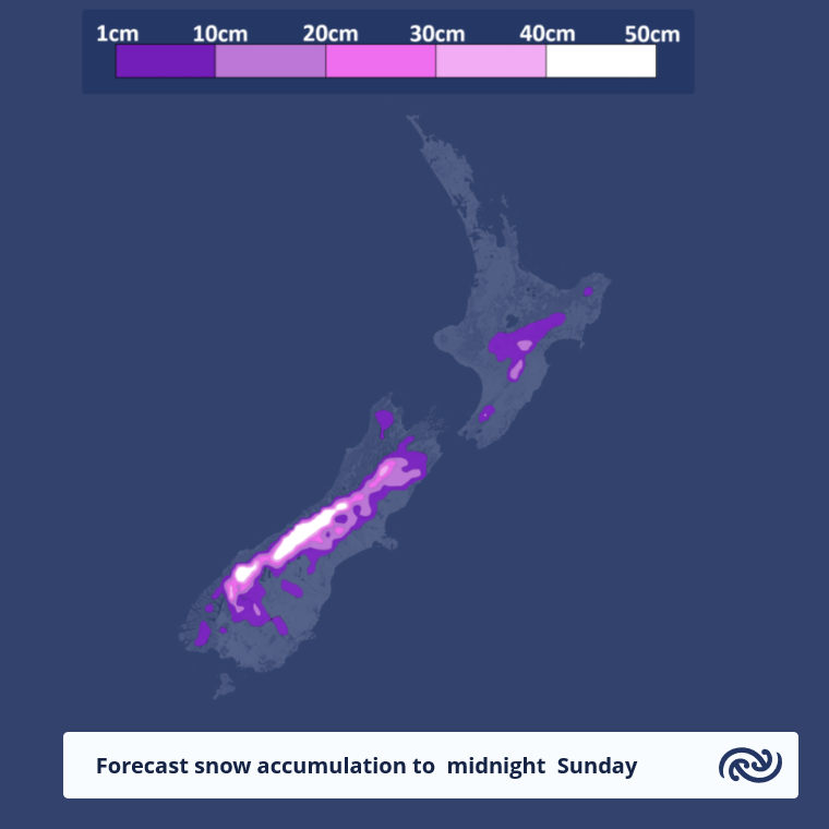
Gales and snow this weekend
MetService News Release
15
August 2019
Gales and snow this
weekend
MetService is forecasting gales and snow this weekend following settled weather today and tomorrow.
MetService meteorologist Andy Best says, “An active cold front over the Southern Ocean is expected to move onto southern New Zealand by the end of Friday.”
“Expect strong northwesterlies to develop over the South Island ahead of the front, and showers in the west of the island turning to rain, with possible heavy falls in the west. The remainder of the country on Friday can expect northwesterlies, with only a few showers in the west.”
“On Saturday however, the cold front moves north over the South Island during the morning, reaching Cook Strait around midday and bringing a band of rain, with snow lowering to around between 400 and 500 metres in the east of the South Island. The front and rain band are expected to continue moving north Saturday evening,” adds Best.
Heavy rain is expected to affect the Tararua Ranges Saturday evening, with snow lowering to 600 metres at night, possibly affecting the top of the Remutaka Hill Road Sunday morning.
Sunday sees the front continuing to move north, followed by strong, cold, showery southeasterlies. Snow is expected to affect high level roads in the Gisborne, Hawkes Bay and Wairarapa districts, including the Desert Road,” says Best
“The southeasterlies and showers are expected ease over the South Island during Sunday, as a ridge builds over the southern half of the island, leading to a cold night for many inland places. For example, Ashburton and Queenstown residents will wake up to a frosty -4C Monday morning, with widespread frosts elsewhere”
The ridge is forecast to move north during Monday, and the showers over central and southern areas should become few and far between. Periods of rain and strong southeasterlies over the upper North Island should slowly ease during Monday.
Keep appraised of any severe weather expected over the weekend, by visiting our Severe Weather Outlook webpage at http://bit.ly/SWOutlook and monitor our Severe Weather Watches and Warnings webpage at http://bit.ly/AllWarnings.
MetService, has refreshed its website to make it even easier for New Zealanders to get the weather information they need. From today, the new look website beta.metservice.com is available to preview, with MetService encouraging people to check it out and provide their feedback to website@metservice.com. The refreshed site will run concurrently to the original website over the coming months.
 University of Auckland: Junk Food Designed To Make Us Eat More, Study Finds
 Spark: New Report Sets Out Outcomes-Led Approach To Lift Rural Connectivity Using The Right Mix Of Technologies
 Bill Bennett: Fixed Voice Rules Head For Deregulation
 UN Department of Global Communications: United Nations Proposes New Global Dashboard To Measure Progress Beyond GDP
 Banking Ombudsman Scheme: Fraud Check Delays Well Worth The Inconvenience, Says Banking Ombudsman
 Asia Pacific AML: NZ’s Financial Crime Gap - Beyond The 'Number 8 Wire' Mentality