 Scoop has an Ethical Paywall


February Dominated By A Historic Storm Mid-Month
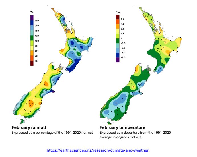
February will be remembered for the “Valentine’s Storm” – a low-pressure system originating in the subtropics which deepened dramatically as it stalled near and to the east of the country in the middle of the month. Another low-pressure system with more limited impacts opened the month, and these two depressions dominate the overall monthly pressure anomaly. However, in between these systems there were some prolonged periods of settled weather over New Zealand. La Niña conditions continued through most of the month of February, but were approaching ENSO neutral by the end of the month. Sea surface temperatures (SSTs) surrounding New Zealand were extremely variable during the month, exhibiting warming trends during settled periods only to cool dramatically in response to unsettled weather, especially around the middle of the month. At the end of February, Marine Heatwave (MHW) conditions1 were absent from New Zealand coastal waters, but a broad and significant MHW persisted in the subtropical waters to our northeast. This MHW originated in November and continued to influence our weather on occasions during February.
The nationwide average temperature in February 2026 was 16.9°C. This was 0.5°C below the 1991-2020 February average, and it was the coolest February since 2012.
The month started with tropical air moving over the northern half of the country, with the highest air temperatures and dew point temperatures of the month recorded during this period. Cold air moved onto New Zealand in the wake of the two low pressure systems, leading to some notably low daytime temperatures in eastern parts of the country.
Overall, February featured lower than normal air pressures directly over the country. However, this anomaly only represents the most significant weather systems of the month, obscuring the fact that there were several periods of slow-moving high pressure systems over New Zealand. This resulted in rainfall that was dramatic in intensity and fell on a relatively small number of days in the month (“boom or bust” rainfall patterns). Rainfall was above average or well above average for areas exposed to these two significant weather systems – areas in the east of both islands, and the central North Island.
Further Highlights:
• The highest temperature was 33.6°C, observed at Hastings on 2 February.
• The lowest temperature was -0.7°C, observed at Waipara River North Branch on 28 February.
• The highest 1-day rainfall was 243 mm, recorded at Akaroa on 16 February.
• The highest wind gust was 241 km/h, observed at Cape Turnagain on 16 February.
• Of the six main centres, Tauranga was the sunniest, Auckland was the driest and warmest, Wellington was the wettest, and Dunedin was the coolest and least sunny.
• The sunniest four regions in 2026 so far are wider Nelson (555 hours), Taranaki (536 hours), Bay of Plenty (535 hours), and Tasman (529 hours).
Note:
1) Defined as five or more consecutive days with SSTs above the 90th percentile for the time of year.
 Gordon Campbell: On The Political Panic Over Immigration
 Internal Affairs: Citizenship Test For Citizenship By Grant Applicants From Late 2027
 Dayenu: Condemning Use Of Government Funding For Extremist Report On Antisemitism
 PSA: Councils Must Work With Unions And Communities In Fast-Track Reform
 Tauranga City Council: Mauao Restoration Work Has Begun
 Horizon Research: New Poll Finds High Concern About Fuel Situation
 Tiaki Wai: Over 1,150 People Give Feedback On Tiaki Wai Water Services Strategy