 Scoop has an Ethical Paywall


NIWA's Hotspot Watch - 6 March 2026
Recent rainfall and current soil moisture conditions:
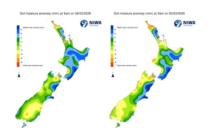
In the North Island, weekly rainfall totals of 30 to 50 mm were recorded for southern Gisborne, the north and east of the Hawke’s Bay region, about Tongariro in Manawatū-Whanganui, and in Northland about Whangārei. Elsewhere, the remainder of the North Island recorded 10 to 30 mm of rain over the past seven days, while a few locations received no rainfall at all. A moderate to large decrease in soil moisture occurred across the north of Northland, Auckland, Waikato, Taranaki, central Hawke’s Bay, and coastal Bay of Plenty. For the remainder of the North Island soil moisture stayed the same or decreased slightly. The driest soils, when compared to normal for the time of year, are found about Cape Reinga in Northland, with the wettest soils, when compared to normal for the time of year, are in coastal areas of Wairarapa and the Tararua District.
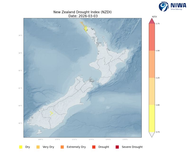
The hotspot about the Manawatū-Whanganui coast near Foxton has strengthened while the hotspot in Northland about the Far North has grown. An additional hotpot has developed in the Bay of Plenty just east of Whakatāne. As of 3 March, the New Zealand Drought Index (NZDI) map shows abnormally dry to very dry conditions in the Far North of Northland.
In the South Island, weekly rainfall totals of 30 to 50 mm were recorded about the Otago Peninsula and across Canterbury from Ashburton northward to Kaikōura. The remainder of the South Island recorded 10 to 30 mm of rain over the past seven days, with some locations recording no rainfall. Soil moisture increased slightly or remained the same across Canterbury and Otago. For the remainder of the South Island soil moisture saw small to moderate decreases. The driest soils in the South Island, when compared to normal for the time of year, are in Westland about Hokitika, Reefton, and Karamea, and east of Richmond in the Marlborough region. The wettest soils, when compared to normal for the time of year, are in North Canterbury about Kaikōura and Banks Peninsula.
The previous hotspots in Southland and Otago have dissipated, while the hotspot along the Nelson Tasman border with Marlborough east of Richmond has grown. As of 3 March, the New Zealand Drought Index (NZDI) map shows a very small area of abnormally dry conditions in Central Otago.
As of 3 March, the New Zealand Drought Index (NZDI) map shows abnormally dry to very dry conditions in the Far North of Northland and abnormally dry conditions in a very small area in Central Otago.
Please note: some hotspots in the text above may not correspond with the NZDI map. This difference exists because the NZDI uses additional dryness indices, including one which integrates the rainfall deficit over the past 60 days. Changes are therefore slower to appear in the NZDI compared to soil moisture anomaly maps that are instantaneously updated.
The week ahead:
In the North Island, high pressure will bring settled weather from Friday through Sunday (6-8 March). A weak front moves across the North Island Monday and Tuesday, with showers for eastern parts of the North Island. Later in the week, low pressure is expected to develop northwest of the North Island, allowing for a moist, easterly wind flow to bring rain and showers to the north of the North Island, mainly on Wednesday and Thursday, with mostly dry weather elsewhere. There is large uncertainty where and exactly when the low pressure will impact New Zealand next week, so there is lower than usual forecast confidence for the weekly rainfall totals. Weekly rainfall totals of 30 to 50 mm are expected for Northland, with the possibility of larger totals of up to 80 mm depending on the development of next week’s low pressure. Elsewhere, the remainder of the North Island is expecting 10 to 30 mm of rain, with the potential for some areas to see 10 mm or less.
Due to the expected rainfall in the next week, soil moisture will likely remain the same or increase slightly across Northland, while soil moisture levels will likely see moderate to large decreases across the rest of the North Island. The hotspots in Manawatū-Whanganui and Bay of Plenty will likely strengthen over the next week, while the hotspot in Northland may weaken based on current forecast rain projections.
In the South Island, a front moves into the lower South on Friday with a period of rain and showers, heaviest about Fiordland. The front weakens by Saturday, and high pressure builds into the upper South Island, with another front moving in on Sunday. The Sunday front brings northwest winds and
more rain and showers to the west and south of the South Island. On Monday (9 March), the front moves north and weakens, with a few showers across the central and upper South Island, as high pressure builds into the lower South Island. The high pressure brings mostly settled weather Tuesday and Wednesday, followed by another front overnight Wednesday and Thursday, which is set to bring more rain to the south and west of the South Island. Weekly rainfall totals of 30 to 50 mm of rain are forecast for the west and south of Southland and Westland south of Harihari, with 100 to 250 mm of rain for Fiordland and the foothills of Westland. The remainder of the South Island is forecast to receive 30 mm or less, with potentially 10 mm or less across Canterbury, Marlborough, and Nelson Tasman over the next week.
Due to the expected rainfall in the next week, soil moisture levels will likely increase across Fiordland. Elsewhere, soil moisture is likely to remain the same or decrease slightly for southern Westland and Southland. For the remainder of the South Island, soil moisture levels are likely to see a small to moderate decrease. The hotspot in Nelson-Tasman and Marlborough will likely strengthen and grow over the next seven day period. Additional hotspots may form in Otago and South Canterbury.
Long-term outlook (through early-April):
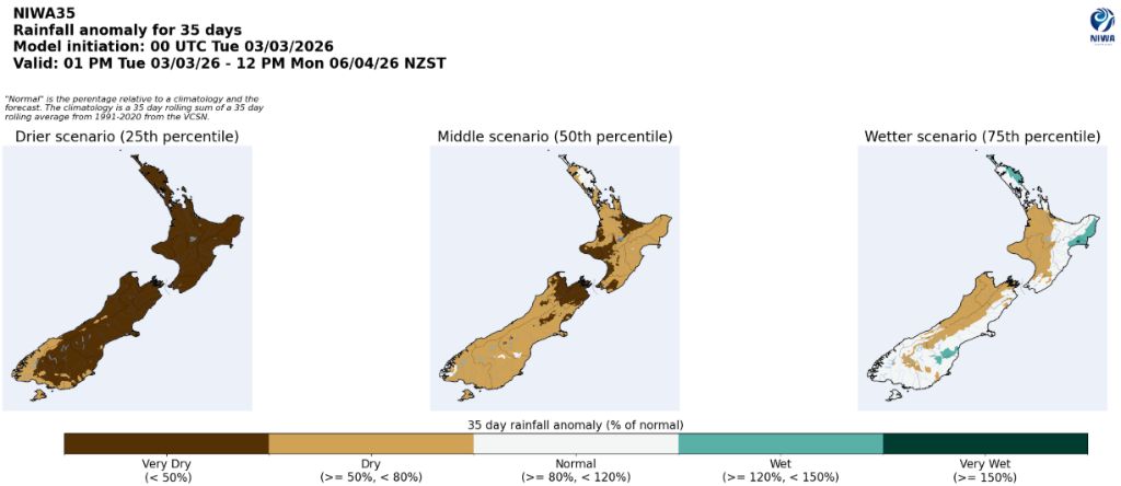
• In the drier (25th percentile) scenario, drier than normal conditions are signalled for the entire country, with very dry conditions for all regions of the South Island except coastal Southland and Fiordland, and for all of the North Island.
• The middle (50th percentile) scenario shows drier than normal conditions for all of the South Island, including a very dry signal for Nelson-Tasman and Marlborough, and dry conditions for all of the North Island except eastern Northland, with a very dry signal for the Bay of Plenty and from Taranaki southward to western Wellington, with near normal conditions for eastern Northland.
• In the wetter (75th percentile) scenario, dry conditions are signalled for the north and west of the South Island and for the central and west of the North Island, while wetter than normal conditions are indicated for eastern Northland and the east of the North Island, and near normal conditions elsewhere.
Background:
Hotspot Watch: a weekly advisory service for New Zealand media. It provides soil moisture and precipitation measurements around the country to help assess whether extremely dry conditions are imminent.
Soil moisture deficit: the amount of water needed to bring the soil moisture content back to field capacity, which is the maximum amount of water the soil can hold.
Soil moisture anomaly: the difference between the historical normal soil moisture deficit (or surplus) for a given time of year and actual soil moisture deficits.
Definitions: “Extremely” and “severely” dry soils are based on a combination of the current soil moisture status and the difference from normal soil moisture (see soil moisture maps at https://www.niwa.co.nz/climate/nz-drought monitor/droughtindicatormaps)
Hotspot: A hotspot is declared if soils are "severely drier than normal" which occurs when Soil Moisture Deficit (SMD) is less than -110 mm AND the Soil Moisture Anomaly is less than -20 mm.
 Gordon Campbell: On The Political Panic Over Immigration
 Internal Affairs: Citizenship Test For Citizenship By Grant Applicants From Late 2027
 Dayenu: Condemning Use Of Government Funding For Extremist Report On Antisemitism
 PSA: Councils Must Work With Unions And Communities In Fast-Track Reform
 Tauranga City Council: Mauao Restoration Work Has Begun
 Horizon Research: New Poll Finds High Concern About Fuel Situation
 Tiaki Wai: Over 1,150 People Give Feedback On Tiaki Wai Water Services Strategy