 Scoop has an Ethical Paywall


Severe Weather Watches issued for Cyclone Gita
Severe Weather Watches issued for Cyclone Gita
Cyclone Gita, currently a Category 3 Tropical Cyclone south of New Caledonia, is expected to move southwards over the next couple of days, and curve towards New Zealand. During its journey, it will weaken to a Category 2 Tropical Cyclone, before it undergoes a transition into an extra-tropical cyclone when it reaches about latitude 35S.
MetService Meteorologist Claire Flynn stressed that, although it will lose its status as a tropical cyclone, Cyclone Gita will still be a significant low pressure system, bringing severe weather to many parts of the country. “It will maintain storm force winds around the centre of the storm, and possibly reach hurricane force,” said Flynn. “New Zealanders need to be aware that, while it will no longer be a tropical cyclone, that does not mean it has weakened or dissipated.”
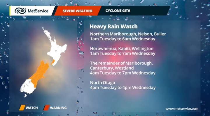
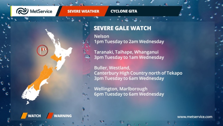
Cyclone Gita is expected to bring severe weather to many parts of New Zealand during Tuesday and Wednesday, with the centre of the cyclone passing over the upper South Island overnight Tuesday/Wednesday. On Sunday morning, MetService has issued the first batch of Severe Weather Watches, giving details on which areas are most at risk of severe weather during the passage of Cyclone Gita. A Watch for heavy rain is in force for Horowhenua, Kapiti Coast and Wellington, and the South Island as far south as North Otago. A Watch for severe gales has been issued for parts of the central and lower North Island, as well as the upper South Island, Westland and Canterbury High Country. The full details of these Severe Weather Watches can be found here. In addition, there is a risk of coastal inundation, particularly for areas where strong onshore winds, large waves, and high tides combine overnight Tuesday.
“Many of these Watches will likely be upgraded to Warnings, and more areas could be added,” Flynn said. “Watches and Warnings are reviewed every 12 hours, and more often when necessary, so people are advised to keep up to date with the latest issues of Watches and Warnings. People in the areas highlighted by these Watches need to take time to prepare.”
There are a number of steps people can take to prepare for severe weather, including checking guttering, tying down unsecured items outdoors or moving them inside, checking moorings of boats, and making sure you have an emergency plan in place. And of course, keep up to date with the latest issues of Severe Weather Watches and Warnings at metservice.com . You can find further tips on how to prepare on the Get Ready Get Thru website.
 Gordon Campbell: On Children’s Book Classics - The Moomins
 Nelson City Council: Mayor Welcomes Auditor-General Decision Not To Prosecute Councillor
 Johnnie Freeland: Ko Tātou Tātou - Climate Action In Aotearoa Begins With Relationship
 Zero Waste Network Aotearoa: Container Return Scheme Bill Would Double Recycling Rates And Put Money Back In Households
 Wellington City Council: Statement From The Wellington Mayoral Forum On Options For Regional Governance Reform
 MUNZ: TAIC Report On Kaitaki Incident Gives Shocking Picture Of Decline Of NZ Maritime Infrastructure
 Greenpeace: New Climate Report Yet More Reason To Reduce Dairy Herd