 Scoop has an Ethical Paywall


Taranaki Rivers Shrink as Rainfall Stays Away
Rivers shrink as rainfall stays away
1 December
2010 - Two consecutive months of low rainfall have left
most Taranaki rivers and streams at low levels not usually
seen until mid-summer, and some are at the lowest ever
recorded at this time of year.
The Taranaki Regional
Council says a few pasture irrigators have already had to
stop taking water, and the situation is being closely
monitored.
"We have a well-established set of procedures to follow when water shortages occur, and we liaise directly with individual water-take consent holders," says the Council's Director-Resource Management, Fred McLay.
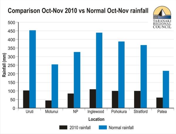
"While September was very wet, we're very concerned that the lack of rainfall in October and November has left rivers so low at such an early stage of the summer," he says. "October is traditionally one of the wetter months in Taranaki, but this time rainfall was between 20% and 50% of normal. November was even drier in places, with between 12% and 50% of normal.
(See graph - click on it for large
version.)
Click for big version
"Most of the rivers we
monitor are already at their mean annual low flow (MALF) -
we don't normally expect to see that until late January or
early February."
The Waitara and Manganui Rivers are at
the lowest levels ever recorded for November, partly
reflecting dry conditions in the eastern hill country where
the Waitara River rises.
"Some areas are more impacted than others," says Mr McLay. "Besides the eastern hill country, the south of South Taranaki and the north of North Taranaki are feeling the brunt. It's not so bad closer to the mountain."
The Taranaki Regional Council monitors rainfall at 25 sites and river levels at 22 sites around the region, with data relayed to its hydrology staff via telemetry links. "So we're constantly monitoring what's happening and can step in to reduce water takes as soon as the situation demands," says Mr McLay.
Rainfall and river-level data from many of the monitored sites are also published live on the Council website, www.trc.govt.nz, along with maps showing monthly and year-to-date rainfall at monitored sites.
ENDS
 Gordon Campbell: On The Political Panic Over Immigration
 MUNZ: TAIC Report On Kaitaki Incident Gives Shocking Picture Of Decline Of NZ Maritime Infrastructure
 Greenpeace: New Climate Report Yet More Reason To Reduce Dairy Herd
 Better Public Media: Opposing Plans To Scrap The BSA
 Internal Affairs: Citizenship Test For Citizenship By Grant Applicants From Late 2027
 Dayenu: Condemning Use Of Government Funding For Extremist Report On Antisemitism
 PSA: Councils Must Work With Unions And Communities In Fast-Track Reform