 Scoop has an Ethical Paywall


A Period Of Heavy Rain For Saturated Eastern Coasts
Covering period
of Thursday 20 - Monday 24
July
MetService is forecasting a shift in winds from westerly to easterly today and tomorrow with eastern coasts of the country set to see some wet weather in the next few days. The rain will affect vulnerable regions from Northland down to Hawkes Bay which are already under Heavy Rain Watches or Warnings.
MetService meteorologist April Clark says, “A broad area of low pressure currently west of the North Island will be the major driver of the weather over the next four days, pushing a band of heavy rain and strong northeasterlies over the upper North Island (including Gisborne) today and tomorrow.”
“The first match of the FIFA Women’s World Cup at Eden Park is likely to see fans dry at kick-off but in light rain by the final whistle. The main rainband is expected to cross Auckland soon after the game finishes, with a Heavy Rain Watch in force over the area from 8pm tonight, so be prepared for hazardous driving conditions if you have a longer commute home,” Clark warned.
Orange Heavy Rain Warnings are out for Gisborne and Coromandel starting tonight or tomorrow morning, with 24-hour rainfall accumulations of 100-150mm possible. This unwelcome rain could quickly cause surface flooding, slips and hazardous driving conditions so keep up to date with advice from your local emergency providers if you live in these areas.
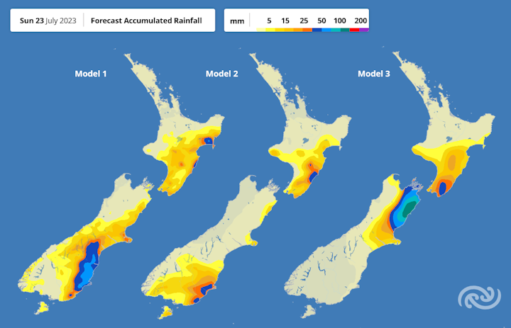
As the low moves east of the North Island over the weekend the focus of the strong winds and heavy rain drifts south and becomes wider, affecting eastern regions from East Cape to Bluff. While the details for Saturday’s forecast from Gisborne to Christchurch all agree on some amount of rain, Sunday’s forecast is a lot more uncertain (see image below). Exactly where and how heavy the rain will be in the east varies significantly at present, so checking the forecast over the next couple days as these details become clearer is important.
It's not all rain and gloom, with western regions south of Taranaki looking to see a mostly dry few days, while the upper North Island will see a good clearance of the rain and an easing of the winds into the weekend. As always, for more details for your city or town head to metservice.com.
 Gordon Campbell: On How US Courts Are Helping Donald Trump Steal The Mid-Terms
 Office of the Ombudsman: Ombudsman Publishes Findings On Ministry Of Education Sensitive Claims Scheme
 Nelson City Council: Mayor Welcomes Auditor-General Decision Not To Prosecute Councillor
 Johnnie Freeland: Ko Tātou Tātou - Climate Action In Aotearoa Begins With Relationship
 Zero Waste Network Aotearoa: Container Return Scheme Bill Would Double Recycling Rates And Put Money Back In Households
 Wellington City Council: Statement From The Wellington Mayoral Forum On Options For Regional Governance Reform
 MUNZ: TAIC Report On Kaitaki Incident Gives Shocking Picture Of Decline Of NZ Maritime Infrastructure