 Scoop has an Ethical Paywall


Hot Weather Continues
Covering period
of Thursday 11 - Sunday 14
January
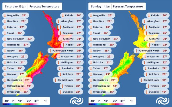
MetService is forecasting high temperatures to endure through the weekend, with warm northwesterlies developing again on Saturday – a repeat of the current set up over the South Island/Te Waipounamu, while a ridge dominates the situation in the North Island/Te Ika-a-Māui.
A warm, moist northwesterly flow is delivering rain to the west and the south of the South Island today (Thursday), resulting in a Heavy Rain Watch for southern Westland until Thursday evening. The flow dries out and heats up as it travels over the Southern Alps in a classic foehn wind scenario, pushing up the mercury as it reaches eastern areas – Christchurch reached 31°C early Thursday afternoon as the hot air touched down in the Garden City.
Up north, the settled and mostly sunny days continue into Friday for the North Island/Te Ika-a-Māui: temperatures about average; showers mostly isolated and inland; morning clouds giving way to blue skies. While northwesterly winds pick up on Thursday evening for the lower North Island, they drop out again Friday morning.
MetService Meteorologist Clare O’Connor expands: “A weak cold front travels up the South Island overnight into Friday bringing about a change to easterly winds on Friday morning and low cloud pushing onto the east coast with the return of ridge conditions. This wind change will also be felt over in the west, with the dying out of the northerly winds and the sun poking through by afternoon there. North Islanders will be mostly unaffected, aside from cloudier conditions to start about the Kapiti Coast and Wellington.”
The ridge over the South Island is short-lived, and another warm, moist northwesterly flow develops Saturday morning and travels northwards up the country. MetService’s Severe Weather Outlook signals heavy rain affecting the south and west of the South Island again from Saturday afternoon; any necessary Severe Weather Watches or Warnings will be issued closer to the time. Temperatures are forecast to rise once more in the east of the South Island, but the east of the North Island will feel it too this time: models are currently indicating that Hastings could reach 33°C on Sunday.
MetService advises anyone out and about in the sunshine over the next few days to remain sun smart: slip, slop, slap, and wrap, and make sure you have sufficient fluids to keep you hydrated. Heat alerts will be issued for locations that are reaching their highest temperatures – keep up with your local forecast to make sure you are the most prepared you can be for the day.
But cooler air is on the horizon: “A fresh southwesterly change early Monday will be in sharp contrast to the hot weather of the weekend – maximum temperatures are forecast to barely reach the high teens early next week, in some places this is even lower than recent overnight temperatures, which might be appreciated by anyone who has been struggling to sleep this last week.” O’Connor says.
 Gordon Campbell: On Children’s Book Classics - The Moomins
 Wellington City Council: Statement From The Wellington Mayoral Forum On Options For Regional Governance Reform
 MUNZ: TAIC Report On Kaitaki Incident Gives Shocking Picture Of Decline Of NZ Maritime Infrastructure
 Greenpeace: New Climate Report Yet More Reason To Reduce Dairy Herd
 Better Public Media: Opposing Plans To Scrap The BSA
 Internal Affairs: Citizenship Test For Citizenship By Grant Applicants From Late 2027
 Dayenu: Condemning Use Of Government Funding For Extremist Report On Antisemitism