 Scoop has an Ethical Paywall


A Wet Week Ahead For Aotearoa New Zealand
08/04/2024
Covering period of Monday 8th -
Friday 12th April
MetService is forecasting a significant weather event to unfold over the coming week, which looks set to bring heavy rain and strong winds to many parts of Aotearoa New Zealand. The heavy rain is expected first over the western South Island from Tuesday, then spreads to the eastern South Island midweek, reaching the North Island by the end of the week. This sharp pivot will be a marked change after what has been a relatively calm few weeks.
The weather system moves onto Fiordland early Tuesday morning and becomes slow-moving in Westland on Wednesday and Thursday, delivering a lot of rain to the area. Numerous Watches and Orange Warnings have been issued for Heavy Rain.
MetService meteorologist Mmathapelo Makgabutlane elaborates: “The ranges of the Westland District south of Hokitika, which are under an Orange Warning, can expect rainfall amounts of 600 mm to 800 mm between Tuesday and Thursday, with lesser amounts near the coast. This is a significant heavy rain event, and we will be keeping a close eye on developments over the next 24 hours as there is the potential to upgrade to a Red Warning. Rain of this amount may cause streams and rivers to rise rapidly. Surface flooding and slips are also possible and driving conditions may be hazardous.”
Other areas in the South Island are also under Orange Warning or Watch, which may be upgraded in the coming days.
The rain extends northwards to the top of the South Island from Thursday and onto the North Island Thursday into Friday.
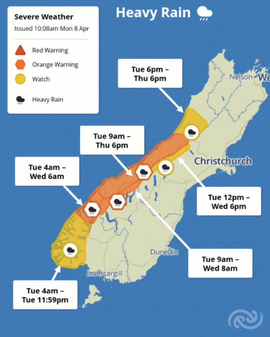
“While it’s still early days, there is the potential for Heavy Rain for places like Tasman, as well as the central North Island. In fact, the whole northern half of the North Island, including Auckland and Northland could be in line for a period of heavier falls as the system moves through on Friday,” Makgabutlane says.
The system also spreads rain eastwards to potentially affect Southland, Otago and Canterbury by the end of the working week.
“This is an evolving situation and is a large weather system with a widespread reach, and anywhere under a Watch, Warning, or highlighted in the Severe Weather Outlook should brace for a wet few days,” Makgabutlane advises.
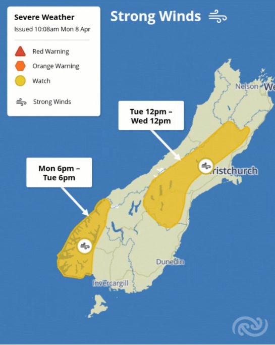
Watches for Strong Winds have also been issued for Fiordland and the Canterbury High Country between Monday and Wednesday for possible severe gales. Several other areas across the country may be in line for some strong winds this week. Large waves across the western and eastern coastlines of the South Island are likely on Thursday and Friday as a result of the strong winds and low pressure associated with this weather system combined with the King Tides.
“Wherever you are in Aotearoa New Zealand this week, be sure to keep an eye on the weather, as this system will affect all parts of the country to varying degrees,” Makgabutlane advises.
 Gordon Campbell: On Children’s Book Classics - The Moomins
 Zero Waste Network Aotearoa: Container Return Scheme Bill Would Double Recycling Rates And Put Money Back In Households
 Wellington City Council: Statement From The Wellington Mayoral Forum On Options For Regional Governance Reform
 MUNZ: TAIC Report On Kaitaki Incident Gives Shocking Picture Of Decline Of NZ Maritime Infrastructure
 Greenpeace: New Climate Report Yet More Reason To Reduce Dairy Herd
 Better Public Media: Opposing Plans To Scrap The BSA
 Internal Affairs: Citizenship Test For Citizenship By Grant Applicants From Late 2027